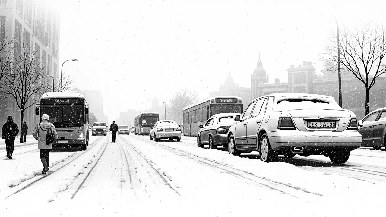
Norway's weather has shifted dramatically, sending temperatures from deep freeze to near-thaw and triggering heavy snowfall across the south and east. The Meteorological Institute has issued a yellow warning for up to 20 centimeters of snow in Oslo, Akershus, and parts of Buskerud and Østfold, with similar alerts for coastal regions from Agder to Vestfold. This rapid change, bringing snow, ice, and rain, is creating hazardous conditions just as the evening commute begins.
“It has been below freezing for an extended period. Now there is a weather shift during the afternoon and evening with milder air near the coast,” said state meteorologist Espen Biseth Granan. He warned that precipitation will increase, potentially falling as rain in coastal areas that have been cold for days. “That can lead to slippery conditions,” Granan stated, recommending that people wear ice grips or studded shoes if venturing out.
A Recipe for Slippery Roads
The Norwegian Public Roads Administration is mobilizing all available resources, salting roads as much as possible in preparation for Tuesday evening and Wednesday morning. “The crews will keep it going as long as necessary,” said traffic operator Øyvind Eik. Despite these efforts, he cautioned that roads could remain slushy and treacherous. “It can be slushy even if it is plowed and salted,” Eik explained. The agency has explicitly warned of challenges for the Wednesday morning rush hour, particularly on routes into Oslo and Østfold, urging drivers to allow extra time and show consideration for other road users and maintenance crews.
This warning comes after a day of traffic incidents linked to the changing conditions. Several rear-end collisions were reported Tuesday in Indre Østfold, Drammen, and Nes, though no injuries resulted from these accidents. The incidents underscore the immediate danger posed by the sudden shift, where drivers accustomed to dry, cold roads are caught off guard by new snow and ice.
The Science Behind the Sudden Shift
The current situation is a classic example of a Norwegian coastal low-pressure system clashing with entrenched cold air inland. For days, a high-pressure system over Scandinavia has kept southern and eastern Norway in a deep freeze. Now, a milder, moisture-laden air mass from the southwest is advancing, creating a sharp boundary. Where this mild air overrides the cold layer near the ground, precipitation falls. In inland areas, where the cold air holds firm, this means heavy snow. Along the coast, where the mild air penetrates more easily, rain falls onto frozen surfaces, creating instant ice.
“The weather shift has not fully set in yet, but according to the meteorologist, it will kick in properly during the afternoon and evening. First out is Agder,” the forecast notes. This progression means the worst conditions will develop through the night, catching many by surprise at dawn. The combination of fresh snow, potential freezing rain, and the compacting effect of morning traffic creates what road engineers call “the perfect storm” for slippery roads.
Infrastructure and Economic Ripple Effects
Beyond the immediate traffic snarls, such weather events have a tangible economic impact. Major logistical corridors into the capital, like the E6 and E18 highways, experience significant delays. Public transport, particularly buses and trams in Oslo, often faces disruptions, leading to workforce tardiness and lost productivity. Oslo Airport Gardermoen must also increase de-icing operations, potentially causing flight delays that ripple through the national and European network.
For the road administration, these events test winter preparedness budgets and resource allocation. A single major snowfall can consume thousands of tons of salt and require round-the-clock shifts for plow operators. The decision to issue a public warning, as done here, is part of a strategy to mitigate impacts by influencing driver behavior, a critical tool when physical resources are stretched.
A Test of Public Preparedness
Meteorologist Granan’s specific advice about footwear points to a broader cultural preparedness in Norway. While such weather is not uncommon, the rapid transition from stable cold to active snowfall is particularly hazardous. Norwegians are generally well-equipped, but authorities consistently emphasize basic precautions: ensuring winter tires are adequate (the studded tire deadline is November 1st), keeping an emergency kit in the car, and, as advised, using personal traction devices.
The yellow-level warning itself is part of a three-tier system (yellow, orange, red) used by the Meteorological Institute. A yellow warning signifies weather that is potentially dangerous and may cause local disruptions, advising the public to be aware and follow situation updates. It is a call for heightened attention, not alarm, but it signals to municipal services and transport agencies to activate their response plans.
Looking Ahead: A Persistent Pattern?
This week’s event raises questions about the broader winter pattern. After a period of stable, cold weather, is this the start of a more active and unpredictable season? Climate scientists note that while linking a single event to climate change is complex, a warming Arctic can contribute to more volatile jet stream patterns, potentially leading to more frequent clashes between air masses in Scandinavia. This could mean an increase in precisely this type of rapid-transition weather event, posing ongoing challenges for infrastructure and emergency planning.
For now, the focus remains on the next 24 hours. The snow will taper off, but the aftermath—compacted snow, refreezing meltwater, and lingering ice in shaded areas—will keep road crews busy and require continued public caution. The event serves as an annual reminder of nature’s dominance in the Nordic region, where society’s sophisticated infrastructure remains perpetually at the mercy of the next low-pressure system moving in from the North Sea. As the lights of plows and salt trucks glow through the night on Oslo’s ring roads, it’s a clear sign that winter, in its most disruptive form, has officially announced its presence in the capital.